Free Writing:
A Sept. 6 KAYAK trip around
SEARS ISLAND or:
"How I discovered America"
What danger lurks behind the fog?
Quickkkk sketched impressions in 10 to 15 minutes
writing freely, unprocessed, plenty of mistakes
That's what makes "free writing"
Frederic A. Moritz
Measuring the risks
Discovering America
A Moritz kayak view of Sears Island
A guide to kayak trip: around Sears Island
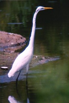
Identify that bird
Moritz kayak
Download essay in .pdf file
It was 8:30 am, about the time Weather Radio had predicted the fog would lift.
Low tide would come at 1pm...
And so it was time to put the Osprey in, on the left side, just before the causeway from Searsport to Sears Island....
What danger lurks behind a possible morning fog? Plan carefully, think sharp. Trust in your sturdy "Osprey."
The state of Maine owns the island, and closed off the causeway road from the mainland to the island....until a decision is made on how to use this giant island.....
And so I had found a deserted overgrown road leading off to a beach to the left or east of the island....And once the "Osprey" was in the water, the car could be parked back up on the main road to the causeway...
And off I paddled, as the fog lifted out into Stockton Bay with a panorama of gulls and buoys and far in the distance the other side of the Bay enshrouded in the gently lifting steaming morning fog.
South I paddled and wove our way sometimes out into the Bay, sometimes closer to the causeway but leaving a patch of wide open water behind us to the beach of embarkation......
The water was mirror calm on this, the sheltered part of the island. The causeway faded in the distance and the open Bay of Stockton and the mouth of the Penobscot which winds its way to Bucksport loomed far head.....
In the distance are platforms sunken into the Bay -- where freighters ply their way up to Bucksport to the paper mill there.....
And now I am in my stride as small groups of gulls clumped on the waters to entertain us -- and the clear sun began to illuminate the Bay ahead.
Sears Island to our right seemed to stretch forever, as the feeling of exploration set in. Out of sight to the rear now was the causeway and the beach where I put in.......And very distant on the Sears Island shore was the rocky path open to hikers who wished to circumnavigate the island by hiking......
And now I was paddling clockwise to round old Sears, to head out into the open Penobscot Bay where the waters would be unsheltered, the "seas" less predictable....
MEASURING THE RISKS
Before embarking I had a chat with two middle aged women hiking near the Causeway. They warned me to be careful, for the son of one had capsized the week before while rounding Sears Island in his kayak.
Morning reports from Weather Radio left me sure the waves would be no more than two feet -- well within the established capacity of the "Osprey." Still, I took it carefully, to be sure I did not stray into rough waters beyond my capacity, beyond my control....
With low tide not until 1pm the danger of straying onto treacherous hidden rocks or sandbars was minimal. But it was necessary to keep a sharp eye out for indications of shallow water whenever exploring closer to shore.
To go far into the Bay one had to gauge the winds, the waters, the size of possible waves. To explore closer into the island, one had to watch for bottom, for signs of rocks which might catch me, scrape me, or worse.....But there was no sign of treacherous currents.
So I was able to focus far ahead on a corner protrusion of Sears into the Bay. Where dozens, hundreds of gulls and ducks covered the island with scarcely any left over room, as the waves lapped around their feet.
Steady they held as the "Osprey" drew closer.......
And then finally, as the gulls grew larger, they suddenly took fright and flight....leaving barren bay washed rocks in their wake. Except for one strange tall "monument" which seemed to stretch into the sky.
It looked so stiff and firm, so tall, so plastic -- it could have been a front yard sign -- or a billboard for a fast food store. Frozen it was, as if erected in cement by park managers as a warning to boats to beware the rocks.
When this kayaker later checked the web, he concluded the mystery bird looked most like an Egret.
But consider again.
The giant "billboard" began to flap its wings, to soar into the air, with its long head and beak flowing, pointing forward like the lance of some knight in King Arthur's Court....like a warplane launched from an aircraft carrier.....
This flying bird of fish hunting war could be the famous giant blue heron, sighted in many parts of America, but in the winter only in the South.....Whatever it was, off it spread to dominate, to control the "airspace" over Sears Island.
(A friend suggested this was indeed the famous blue heron, but the next day my Unity College students came up with other possibilities: an egret, a crane, even a stork)